
Richard G. Smith on Satellites and Cities from Space
In this website supplement to the Theory, Culture & Society special section on the Urban Problematic II (Volume 31 Issue 7-8, December 2014), Richard G. Smith writes about images of cities from space.
Satellites: Cities from Space
Richard G. Smith
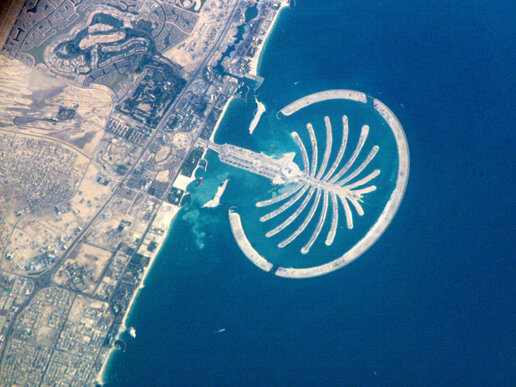
Image: Palm Island Resort, Dubai, United Arab Emirates. Source: NASA.
The world’s cities are watched from space; made present and represented through data and imagery from satellites that are increasing in both number and technological sophistication. Satellite coverage of settlements matters more and more because of its influence on, among other things, the planning, governance and policing of the world’s cities – whatever their size, fame or anonymity. Because the act of representation radically changes what is represented, the fact that satellite technology has overexposed and placed all the world’s settlements ‘on the map’ is profoundly important. Unfortunately, the discourse and practice of remote sensing and satellite observation of cities from space has to date been an overwhelmingly technical issue – concerned with better measurement, resolution, coverage etc. –, neglecting the critical issue of how the data and imagery it produces are utilised and contested by the different actors involved in (re)shaping the spacing and spaces of any of the world’s settlements.
‘It takes a lot of lights to make a city, doesn’t it?’
Veronica Lake to Alan Ladd, The Blue Dahlia (1946)
Satellite images of the Earth at night illustrate a basic truth about the world’s urban geography: that whilst more than 50% of the world’s population lives in cities those settlements nevertheless only cover a small percentage (<2%) of the Earth’s total land surface. Artificial light reveals the human footprint and geographical spread of habitation and economic activity across the planet. The vast interiors of the southern continents of South America, Australasia, and Africa are ‘dark’ reflecting their lack of urbanisation and relative economic insignificance. In stark contrast, the northern hemisphere – especially North America, Europe, and East Asia – is considerably ‘brighter’ indicating higher economic prosperity and more developed urban systems. Overall, a global pattern of cities spanning the globe is identifiable; a broad swath of light girdles the mid-latitudes of the northern hemisphere, elsewhere islands of light are dotted – especially along the coastlines of the world’s continents.
It is a common misconception that the Great Wall of China is the only ‘man-made’ feature visible from space. A satellite image of the Earth at night shows that the world’s cities are also highly visible. Settlements appear at night as pin-pricks of electric light on a black canvas. The world’s major metropolises are especially prominent, the largest and brightest pin-pricks, with cities such as Johannesburg, Cairo, Madrid, London, Paris, Los Angeles, Seoul, Sydney, New York, and São Paulo, to name just a few, being easily identifiable as they are aglow with electric and fluorescent light. The discontinuous urban complex of the north-eastern seaboard of the United States, famously described by Jean Gottmann as a ‘megalopolis’, is also clearly identifiable; a ribbon of light stretching some 600 miles from approximately Richmond in Virginia up to Portland in Maine, and inland to the Appalachian Mountains the megalopolis captures the metropolitan areas of Washington D.C., Baltimore, Philadelphia, New York and Boston. Furthermore, one can easily deduce other man-made structures: for example, the sweep of light across the Russian Federation tracks the economic life of those settlements that line the Trans-Siberian railway network which spans over 9000 kilometres from Moscow and European Russia to Vladivostok and the Russian Far East.
The first satellite was launched in 1957. Today there are more than 3,000 satellites – military, scientific, and commercial – in orbit; up to some 36,000 kilometres above us they are photographing every square metre of the Earth’s surface in considerable detail. In the 1990s a new generation of satellites were launched, armed with specialist instruments (cameras and digital sensors), to collect massive quantities of data for scientific and technical needs. Through them, and from photographs from the International Space Station, the world’s cities are viewable as never before. The satellites occupy orbits at different distances from the Earth, and consequently each satellite provides a different image resolution: a low altitude satellite only a few hundred miles up provides high resolution images, whereas a high altitude satellite provides images at a lower resolution. Other satellites are specialised, featuring specialist equipment such as infra-red that enables us to see more than meets the naked eye. One thing is certain: satellites enable us to see and understand our cities in a new way; our urban visions are transformed by them. Indeed, satellite pictures are from a sufficient distance to enable us to see cities in their totality, to apprehend their scale, offering a unique perspective on our rapidly urbanizing world – it is commonly predicted that 66% of the world’s population will be living in cities by 2030, rising to 75% by 2050. Cities are where the action is, and consequently it should be of little surprise that cameras in space are busy photographing them so that they can be located, measured, analysed, surveyed, planned, monitored and supervised.
For Plato the ideal number of citizens for a city-state was 5,045. Similarly, Aristotle considered the ideal city or polis to be one that could be grasped in a single view. However, the humongous demographic and physical size of mega-cities (greater than 10 million inhabitants) and meta-cities (greater than 20 million inhabitants) means that such an ideal vantage point is impossible to grasp, at least from street level. Indeed, with the scale of contemporary metropolises such a total view is impossible even from the tallest of skyscrapers, an ascent of which grants no more than a sense of the incredible dimensions of the world’s largest metropolises. What is more, whilst the convergence of aeronautics and photography has transformed our view of cities from the 1800s onwards, with cameras attached to kites, hot air balloons, and then all manner of aircraft, to get an aerial photography of the ground below, the only way to truly get the ‘big picture’ of large geographical areas of the Earth (such as now occupied by mega and meta cities) is not from the sky, but from space, to be on the outside looking down. Looking back at the Earth from space has produced the first ‘outside views’ of the planet, changing the way we think about life on Earth by bringing, amongst other things, the scale of particular urban geographies to the fore. Satellite images confirm that the stand-out feature of urbanisation in the developing world is the rise of the mega-city. In 1950 only New York-Newark and Tokyo qualified as mega-cities; by 2005 the United Nations could list twenty such cities: New York-Newark, Los Angeles, Mexico City, Rio de Janeiro, São Paulo, Buenos Aires, Lagos, Cairo, Moscow, Karachi, Mumbai, Delhi, Dhaka, Kolkata (Calcutta), Jakarta, Metro Manila, Beijing, Shanghai, Tokyo, and Osaka-Kobe. Thus, mega-cities are mainly a phenomenon of the developing world; it is estimated that by 2020 only four of the world’s mega-cities will be in the developed world. Indeed, whilst Tokyo will remain the world’s most populous city until at least 2015, its rate of growth is in decline; the demographic future of spectacular growth belongs to the Third World mega-cities alone.
Such is the sophistication of contemporary satellites that cities can be photographed down to the scale of a few metres. High resolution satellite image data of individual cities afford a detailed snapshot of their size, form, pattern, heat, density, delineation, composition, exact physical structure (land cover), buildings, and encroachment. Furthermore, a sequence of images of any city over time provides an effective monitoring and record of its urban change with regard to those visible characteristics. What is more, idiosyncratic differences between the technological bases of the world’s cities are evidenced by satellite imagery. For example, Tokyo has a blue-green glow because of its mercury vapour lighting; night-time satellite photos of São Paulo are multi-coloured reflecting the different types and generations of streetlight across the sprawling metropolis.

Image: Brasila. Source: NASA.
The widespread availability of satellite imagery through the internet – through © Digital Globe, Google Earth, for example – brings cities into focus and has consequently helped fuel the desire of some cities to design themselves so as to be photogenic from above, iconic from space. Most famous in this regard today – previously one thought of cities such as Brasilia whose original plan was designed to resemble the shape of an airplane when seen from above – is Dubai, whose building of a number of projects off its shoreline are specifically designed to be so massive in size and form so as escape any earth-bound description. Dubai promotes itself, shows-off an international face, through satellite imagery of its various mega-projects – three man-made ‘Palm Islands’ and ‘The World’ give the city both a multi-billion-dollar frontage on earth and a ‘global signature’ from space. Analogous to Dubai is Las Vegas with its ‘sunbeam’, a brilliant spotlight atop the Luxor pyramid hotel that is visible from outer space. Indeed, the ‘Vegas Strip’ of hotels and casinos is said to be the brightest spot on Earth when looked on from a heavenly perspective.
Whilst a handful of the world’s most developed cities are concerned with their international aesthetic, and chose to play on how they look from above, satellite coverage also affords a glimpse of the uglier features of urban environments: most visibly, the sprawling slums of the developing world’s mega-cities. Recent books on slums (e.g. Davis, 2007; Mute, 2006; Neuwirth, 2006) make no reference to the study and representation of cities with slum settlements from space. This is a considerable oversight because that is how the world’s slums are increasingly being envisioned, monitored, analysed, and represented. For example, the 2008/9 UN Habitat State of the World’s Cities Report discusses how civilian Earth Observation and geoinformation technologies are being used, in combination with field surveys, to differentiate slum and non-slum areas in the world’s mega-cities: ‘Satellite-based remote sensing provides synoptic overviews over settlements and cities and thus an opportunity to locate slum areas. This can prove to be useful when improving census and field surveys. The satellite images can also provide a description and identification of the physical structure of housing and housing patterns, which may be indicators for slum conditions’ (2008: 118).
Photographs from space turn cities into images. Images that are available to a wide variety of audiences. Satellite images do provide a unique perspective on the world’s cities – they can even be combined to provide extraordinary 3D views – and they are increasingly functioning not just as a means to study and monitor urban change but also as representations that are deployed to inform urban discourse and consequently shape the future of cities. However, despite the ubiquity of satellite images (increasingly all manner of fora are decorated by, and interspersed with, photographs of cities from space: book covers (e.g. Steinberg & Shields, 2008), opening sequences for television documentaries (e.g. Searle, 2010), establishing shots within movies (e.g. Scott, 1998), and so on) and their influence in the urban process, the lack of critical attention urban studies has paid to satellite images as a form of representation is palpable. Perhaps this oversight is a consequence of the ‘cultural turn’. In the 1990s it became fashionable to critique the dominant role of vision for understanding the city; researchers chose to shift their focus to the scale of the body to investigate the embodied urban experience. Nevertheless, what is clear is that a critical engagement – a moving forward of the agenda set by Pickles (1995) – with satellite imagery and remote sensing in general as an increasingly influential form of urban representation is urgently required. Necessary, if satellite images are not to be simply adopted by urban remote sensing science (experts only discuss the technical limitations of satellite technology: e.g. see Mesev, 2003; Donnay et al., 2001), and within all discourse, as ‘truthful’ representations of cities and urban life. Uncritically adopted as a technological tool with ‘practical applications’ to unveil the city, reduce its complexity, lay bare its essential truth, whilst conveniently ignoring the power of such remote sensor representations as a rhetoric for interested groups and (in)vested interests to shape the city and persuade key policy makers according to their design, interest, and benefit.
Satellite imagery means that the slums of the world’s mega-cities have been exposed, exhibited, dragged on to the stage of urban discourse to be identified as places that do not necessarily matter, a problem that can be wiped out. For example, satellite images of Lagos not only identify the issue of slum growth, but are also adopted by politicians, urban planners, managers, and boosters for organizing future construction and development. Eye-catching satellite images of the size and scale of slum settlements serve to portray a city as out of control, beset with a cancer that must be eradicated no matter what the cost – increasing homelessness, displacement, unemployment, starvation, isolation, etc. – to the urban body as it has organically grown. Only when its slums, and the people who occupy them, have been converted into a visible ‘problem’ can Africa’s biggest city target them for demolition, and consequently fulfil its urban and economic destiny as a ‘model mega-city’ where presumably more and more of the city’s wealth will be concentrated in the hands of a tiny minority. Indeed, it is the narrative that accompanies satellite imagery that is all important. A more progressive engagement with urban satellite imagery – such as Ursula Biemann’s avant-garde video essay Remote Sensing (2001) on the transnational sex trade, where commentary interprets images from space for the victims, rather than the perpetrators – is required in urban studies in order to aid coordinated social actions from marginalized populations over such issues as disenfranchisement, poor service provision, environmental degradation, and land rights.
Informal settlements are no longer only disenfranchised and subjected to forms of disaffection because they are absent from official maps (e.g. see Myers, 2011), but are increasingly targeted for eviction, eradication, or extraordinary policing because they are made present through satellite imagery. In nuce, the proliferation of images of all the world’s cities from space, and the emergence of a cohort of scientists to produce and analyse those images, is a phenomenon that represents an important agenda for research and action in progressive urban studies: First, to identify the audiences for satellite imagery in cities; who uses such imagery and for what purposes? Second, to ascertain how, and the extent to which, the analysis of satellite images has filtered into and informed policy and planning within individual cities. Third, to understand how the knowledge, expertise and techniques of satellite imagery analysis circulate, perhaps informing and normalising regional, national, or global urban policy and planning discourses. Finally, and most importantly, to move beyond the technical accuracy or ‘ground truth’ (Pickles, 1995) of satellite imagery to explore how such imagery is, and can be, used to empower individuals and groups to assert and secure their rights to the city.
References
Biemann U (2001) Remote Sensing, Film, 53 minutes, English.
Davis M (2007) Planet of Slums. Verso: London.
Donnay J-P, Barnsley MJ, Longley PA eds. (2001) Remote Sensing and Urban Analysis. Taylor & Francis: London.
Mesev V ed. (2003) Remotely Sensed Cities. Taylor & Francis: London.
Mute (2006) Naked Cities - Struggle in the Global Slums. Mute Publishing Ltd.
Myers G (2011) African Cities: Alternative Visions of Urban Theory and Practice (Zed Books, London)
Neuwirth R (2005) Shadow Cities: A Billion Squatters, A New Urban World. Routledge: London.
Pickles J ed. (1995) Ground Truth: The Social Implications of Geographic Information Systems (The Guilford Press, New York)
Scott T (1998) Enemy of the State. Touchstone Pictures.
Searle G (2010) Welcome to Lagos. TV documentary trilogy, BBC Television, UK.
Steinberg P & Shields R eds. (2008) What is a City? New Orleans after Hurricane Katrina. University of Georgia Press.
UN Habitat (2008) State of the World’s Cities 2008/09: Harmonious Cities. Earthscan: London.
Readers may also be interested in:
Theory, Culture & Society Special Section on the ‘Urban Problematic II’, edited by Ryan Bishop and John WP Phillips, Volume 31 Issue 7-8, December 2014.
An earlier section on the ‘Urban Problematic’, edited by Ryan Bishop and John WP Phillips, Volume 30 Issue 7-8, December 2013.
Readers may also be interested in similar material in Theory, Culture & Society on ‘Air Target’ (Volume 28 Issue 7-8, December 2011), ‘Megacities and Violence’ (Volume 27 Issue 6, November 2010), and ‘City as Target’ (Volume 26 Issue 7-8, December 2009).
Richard G. Smith is Co-Director of the Centre for Urban Theory at Swansea University in the UK. His writings have pioneered relational approaches in urban studies and are amongst the most highly-cited in the world.